
BRASS: Burning Risk Assessment Support System
A continuous means for helping land managers assess vegetation, weather and wildfire risk in decision-making related to prescribed burns
Assessing, mitigating wildfire risk
Wildfire risk on rangeland is directly related to the state and condition of the vegetation and weather variables. These communities pose a high potential for wildfires during dry, windy weather conditions. Prescribed burning regimes are increasingly being utilized to mitigate future wildfire risks; however, concerns regarding unpredictable fire behavior have hampered the efforts of land managers and fire professionals. Effective vegetation monitoring and the influence of dynamic weather on potential fire behavior are of key importance in the management of rangelands. The BRASS (Burning Risk Assessment Support System) decision support tool provides a continuous means for land managers to assess vegetation and weather to support decisions related to prescribed burning and/or the risk of wildfire by utilizing near real-time weather conditions and fuel loads.

General System Overview
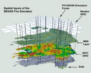
The key management objective of BRASS is to provide a decision support tool to aid in the management of rangelands, prescribed fires and wildfires, and livestock grazing. The system is comprised of three parts, 1) a near-real-time plant growth model, PHYGROW, that is updated daily utilizing current and historical weather conditions from the National Oceanic and Atmospheric Administration (NOAA), 2) a fire simulation model called PHYRESIM, that uses the same core functionality that drives the highly respected BEHAVE Plus burning application, 3) a fire growth model called PHYREFLY that is a derivative of the FARSITE fire growth simulator.
The PHYGROW model provides the fuel loads and live moisture contents on a daily basis for each vegetation polygon in the project area. The PHYRESIM model is then run for each vegetation polygon to simulate dead fuel moisture, spread rate, flame height, and fire intensity. A fire danger advisory map is produced from these values for a forecasted time period of 6 days. The PHYREFLY fire growth model is run on-demand when a fire is presently using the latest available data to predict the area covered by a fire at 30-minute intervals. The PHYREFLY model can be used to simulate fires for a period of up to 6 days.
Interface

Two interfaces for the models were developed to allow maximum flexibility in model usage. The primary interface is a web-based application that can be accessed through a web browser from any computer. The application can be customized to address the needs of the project through the Common Web Interface management software. The software allows for the customized presentation of data, map layers, and user interactivity controls. The second interface is an ArcGIS toolbar application that can be integrated with ESRI products and third-party add-ons to support a multi-tiered customized desktop environment.